Maps: Beautiful Tools at the Root of Water-Friendly Landscape Design
Feb 29, 2024
I may not be a certified cartophile, but I do use maps often in my practice as a landscape designer. Where and how water flows through the land can be difficult to comprehend without one. Plus, they're not only fascinating and informative, but at times quite beautiful.
Particularly impressive are the maps of the Mississippi River drawn by Harold Fisk back in the 1940s. They show not only the route of the river in Fisk's time, but also those from the past. He builds layers of twisting, sometimes overlapping colour coded paths that tell the tale of a dynamic river system over time. They really create a sense of just how impossible water is to predict and control. I can only imagine the hours spent pouring over them as engineers contemplated a way out of the river’s famous levee systems. Admittedly, they also got me thinking about what a modern day equivalent might be. Beyond the costly custom made tech that large engineering and urban development teams have access to…

Thoughtful Design
The human connection to water is deeply rooted. By necessity, where we live, travel, produce food and set up industry are all based on where it can be accessed. In fact, hardly a day goes by that hydrology isn’t dominating news stories around the globe. Whether it’s having too much or too little, finding the right balance affects us all. And, as we work to better understand these complex networks, maps are some of our most valuable tools.
As we develop land, from large-scale construction to minor changes, hydrology has a part in all of it. Not only is it imperative to keep buildings, roads and other human habitat safe and dry (or watered where necessary) but, also to maintain the lands health. Water-based ecosystems are particularly sensitive to change. So, pollution, water extraction (for agriculture, urban and industrial use), disruption (dams, channelization, lack of recharge) and invasive species all have a vast impact on the environment.
When we place structures, utilities and hardscape, choose where plantings will be and make the best use of the land, we can't forget that no site exists in a vacuum. Water will undoubtably move through it, both on the surface and below. So, we use a combination of observation and maps help us to visualize the holistic landscape. With them, we can help predict the cascading effects that alterations have over time.
The same is also true where restoration projects and the redevelopment of urban centres are concerned. What kind of infrastructure to add, where to place it and how it all connects, can make the difference between a sponge city and a catastrophe.
Ecological Functions (Water-based Ecosystems)

These are just a sampling of the interactions that take place thanks to rivers. Additionally, lakes, ponds and wetlands all have their own unique functions and systems that work in seasonal and disturbance related cycles. Which is why more information is always welcome when decisions are being made that involve the landscape.
Complex Interactions

Predicting the how waterbodies will react to our alterations has always been a complicated task. Even as we narrow our focus to rivers, there are complex interactions at work. As an example, the dissipation of the waters force involves;
- Changes in elevation and slope
- Variations in flow rate (seasonal and extreme events)
- Sediment distribution and carriage
- Channel variety and material (turbulence and resistance)
- Discharge (floodplains)
- Storage (hyporheic zones and paleovalleys)
Which is why I usually defer to experts in such matters. And, also why I rely on tools like maps to make informed design choices. Fortunately, gaining free access to a huge cache of relevant data is now easier than ever.
The Joy of Digital Mapping
As you can imagine, the days of Fisk-style cartography are long over. Modern maps have been transformed like everything else, by technology. We have taken the leap from arial photography to satellite imagery. From paper to digital capabilities. And along with this our maps have progressed into complex multi-layered digital systems. Here, we can convey so much more information about our land in a single space. Providing open connections between disciplines and sharing a level of expertise that’s never been freely available to the public before.
ArcGIS (by Esri) is an interactive web-based mapping program that can be used to build and share the most detailed hydrological maps ever. Showcasing a wide range of water dynamics in real time. Layering multiple datasets to build complex maps that can be used to simulate conditions over a wide time period. We can build a digital twin of a city, see how water flowed before construction, how systems are functioning now and how they most likely will in the future. Pinpointing potential issues and mapping out solutions that will allow a more natural flow of water in the future. The possibilities are endless. You can model ancient water systems to glean technologies lost in time. Trial radical new ideas or test out small improvements, all before a shovel hits the ground.
Some of the features that are highlighted include;
- Buried pipes and drainage systems
- Watershed boundaries
- Flow rates/direction and real-time readings from sensors
- Seasonal changes (predicted and historical)
- Real-time weather conditions
- Areas subject to flooding
- Land uses and vegetative cover over time
- Environmental factors and conditions (soils and geology to natural disaster data)
- Ecological zones, wildlife corridors and more
In fact, you can find a huge list of free data sets here, or browse directly on the arcGIS site, it’s pretty mind blowing.

Remember that original map of the Mississippi's flow over time by Harold Fisk? Well, here's the modern version plus an overlay so that you can see how the river has continued to develop and change since Fisk's day.

Keep in mind that the images above are from a single dataset on ArcGIS (National Hydrography Dataset Plus High Resolution). There are literally hundreds of others available with a huge variety of subject matter in precise detail. And, although these screen shots show each dataset individually, they can all be layered together with adjustable transparency. With this system you can build any map that you want and then run comparisons and simulations to your hearts content.


Now that we’ve taken a journey into the cartography of land-based waterbodies, you may be asking yourself, ‘what do we do with this?’ And the answer is, hopefully make changes for the better. From how we view groundwater to how we can mitigate flooding and ease droughts. Plus other issues that are gaining momentum as our climate continues to become more extreme and our engineering projects reach beyond the mega.
Water Mapping and Design In Action
I feel like the future is about seeking balance, building systems that meet the interests of both humans and nature. Including natural processes and nature-based solutions in urban developments. Protecting and restoring ecosystems that are under treat. In other words, we start to value and protect what we've taken for granted in the past.
It’s really through these new mapping systems that we can head off and correct problems. More accurate mapping creates more informed choices which in turn, allows for proactive solutions.
And, you don't have to look far to see a huge variety of projects that are leading the way. There is a paradigm shift happening all around us.
The Slow Water Movement is something worth looking into. It's just what the name implies, slowing the flow of water as it moves through our land. Protecting and restoring what's left in naturalized areas, while Integrating green infrastructure and natural solutions in urban spaces. An over all effort to work with water rather than trying to control it. Green infrastructure Includes, but isn't limited to;
- Connection of fragmented systems
- Bioswales and Rain gardens
- Retention and Infiltration ponds (allowing seepage)
- Parks and greenspaces as a part of the greater water system
- Injection wells
- Daylighting and restoring creeks and streams where possible
- Water treatment facilities
- Making use of natural water storage and recharge areas (paleo valleys)
Creating a holistic system, of many linked smaller parts, building a functional flow of water through cities and landscapes. Additionally, many Slow Water based projects also include pollution treatment, biofuel production and even unusual crop solutions as a part of their layered functionality.
Sponge Cities
In the mid 2010's these special hydro-based cities started popping up in response to the catastrophic flooding seen in many Chinese regions. Created by the team at Turen Design Network, they've brought a great deal of optimism to what can seem like a tough fight. Convincing the central and local governments, developers and residents alike that green infrastructure initiatives are worthwhile.


Restoring streams, meadows and wetlands across California since 2018, with low-tech process-based solutions. Read more about it in their blog, Of Willow and Beaver: Symbiotic Restoration (on virensstudio.com)


Grey to Green Sheffield
An urban revitalization project completed in several phases. Here, a team lead by Nigel Dunnett worked to retrofit several kilometres of Sheffield's busy city centre using SuDS (Sustainable Drainage Systems). Managing stormwater runoff through a series of interconnected, beautifully naturalistic garden spaces.


As you can see, there's a whole spectrum of projects growing out there. And in spite of the limitations and challenges to be met, they, and so many more, are making a meaningful difference in the hydrological systems that they're a part of. All informed by the maps that help us to design, build and monitor each of them. Inspired by cartographers like Fisk; using the best in digital technology.
Additional Resources
- Check your city/area for local digital mapping resources. You can often find maps that show property lines, watercourses, water and sewer lines, drain locations and zoning and more.
- Water Always Wins: Thriving in an Age of Drought and Deluge (Erica Gies, 2022)
Sara-Jane at Virens Studio
Virens is an ecological landscape and planting design studio located in Vancouver, Canada. We specialize in urban greening, consultation and garden writing. Get in touch anytime and don't forget to follow us on Instagram too.
© Virens Studio 2025 (all photos are used for demonstration purposes and do not necessarily belong to us.)
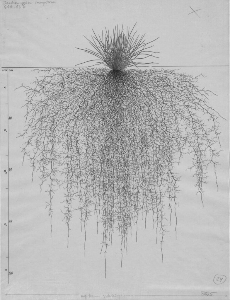
Have you ever wondered why Dandelions are so hard to get rid of? One look at a drawing of its root system says it all. As you can see, they anchor the plant over 4.5m (14′) deep. This startling illustration is just one of the 1100+ invaluable drawings contained in the Wurzelatlas (which translates literally…
Astonishing Root Drawings that Will Elevate Your Planting Designs
What’s a life lived without any vices, dirt or messiness? I might reply, boring. Because, when I think about it, what’s more interesting to witness and be a part of? Think of a classy soirée. Where everyone arrives dressed to impress, with manners to match. On their best behaviour, that is, until late into the…
Are You a Lazy Gardener? Or, a Habitat Hero?
I’ve been working as a gardener and landscape designer for nearly 20 years. In some ways, I find this hard to believe (there’s more to learn) and also totally true (when I think back to some of the things that I was doing in my first years in the Parks Department). But I digress, what…
How I Choose Plants (as a Professional Landscape Designer)
